NSW Unsanctioned Trail Work in the RNP

Steve Mowle

Likes Bikes
Updated NPWS map of trails in the RNP

After the communication between NPWS staff and cyclists and the examination and mapping of many of the singletracks within the Royal National Park in 2013, there has been un updated map of trails within the RNP, issued by NPSW. Included is an extension of the formal mtb trails, including a singletrack in the North East corner of the park, known as The Cliffs Trail. This trail runs from the Temptation Creek Firetrail, past Gore Avenue, Kirrawee, towards the Arcacia Rd Bypass on the Princes Hwy, Sutherland. This trail falls on land owned and controlled by a number of land owners, including National Parks and Wildlife Service and the Roads and Maritime Services.

Like many of the other trails within the RNP, this trail should be avoided during wet conditions.
 

Attachments

higgin_d

Likes Dirt
After the communication between NPWS staff and cyclists and the examination and mapping of many of the singletracks within the Royal National Park in 2013, there has been un updated map of trails within the RNP, issued by NPSW. Included is an extension of the formal mtb trails, including a singletrack in the North East corner of the park, known as The Cliffs Trail. This trail runs from the Temptation Creek Firetrail, past Gore Avenue, Kirrawee, towards the Arcacia Rd Bypass on the Princes Hwy, Sutherland. This trail falls on land owned and controlled by a number of land owners, including National Parks and Wildlife Service and the Roads and Maritime Services.

Like many of the other trails within the RNP, this trail should be avoided during wet conditions.
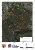
That was not what i had expected to see... that is much of the trail network there...Very nice work Steve !!!!
 

bowtajzane

Likes Dirt
steve, how old is /when did they update the map
I always wondered what that track (cliff track) was called, always do a loop of that and the one that runs along temptation creek,
Crofty, had a laugh when i read the bit about, if you want to lend a hand with their build days in the pfd you posted, if they actually got their shit together we would've still been doing build days out there
 

dcrofty

Eats Squid
Some of those turquoise trails are walking only. I know an audit was done and the map came from that but am unsure that amendments were made to the plan of management to permit an expansion of the previously permitted singletrack. Steve which staff told you that? Im also curious about what permission was gained from the other land owners. Love some more details.
 

Steve Mowle

Likes Bikes
The map was updated at the end of 2013.
The 'Cliffs Trail' and the 'Holy Trail' (which runs from the Loftus loop, parallel to Temptation creek to the Temptation Creek fire trail), were both discussed in detail as potential additions to the RNP singletrack network. So far, only the 'Cliffs Trail' has been added. Towards the end of last year, many of the NPWS/OEH staff were assigned other, more important responsibilities. At this stage, the 'Holy Trail' is still officially a walking trail, however, NPWS/OEH are aware of the high mtb traffic and ongoing care and maintenance being done on the trail by cyclists.
I have been continuing to remain in contact with both Andres and Leigh who were present with us during the two mapping days. I have also stayed in contact with the team who is currently finalising the replacement Cycling Mangaement Plan and the overall Plan of Management for the Royal NP and Heathcote NP.
I have suggested expanding the existing singletrack network within these Parks to 30km.
I have provided NOWS/OEH with maps of many of the well established, well maintained existing trails within the Parks, pointing out the lack of need to design or build any new trails.
Discussions are still under way.
Both walkers and cyclists can benefit from an expansion of the trail network.
I am happy to share the details of my communication off forum for any Park users who like to get involved with the ongoing process and lend support.
 

bowtajzane

Likes Dirt
Steve, top work champ, please keep us posted on any updates,
iv'e been so rapt up with helping out at mill creek I'd almost forgotten
about the park
 

Halo1

Likes Bikes and Dirt
Are the build days still occurring? I use to get emails but have not heard anything for about a year.
 

marc.r

Likes Dirt
dying for a ride today, anyone know the conditions around loftus today? it usually drains pretty well in most places once the surface water is gone but it had a gooood soaking this week.
 

bowtajzane

Likes Dirt
your not the loan ranger on that :llama:
I think i'll leave it till tomorrow........
that's if it doesn't rain today :pray2:
I'm starting to get cabin fever :wacko::wacko:
it's r.i.p to fitness :rip: if i can't get out more than once a week
 

Steve Mowle

Likes Bikes
RNP trail conditions

After speaking with a group who attempted to ride yesterday, despite the lack of rain and a good breeze, many of the singletracks, including the 'holy trail' and 'cliffs trail' are still very wet and should be left to dry for some more time.
Forecast for the rest of the week is more showers from Tuesday morning.
This means the trails will need more time to dry.
Anybody who is able to walk these trails and help aid drainage (clearing leaf and stick build up from creeks and run-offs, cresting drain holes and run-offs from puddles etc) are encouraged to do so. This will help the trails drain and dry.
Seems we will have to be patient.
Are there any other Sydney based trails more suitable to riding atm?
 

bowtajzane

Likes Dirt
went out this morning, still alot of water run off, will take good wether for the rest of the week at least.......
definitely mill creek or if your up for a drive then Kentlyn
are the shizel
 

tjb

Likes Dirt
What is going on in the RNP at the moment ?? Someone has been cutting new singletracks like mad, this time a new loop off "Ziggy and Zaggy", and then a lot of trails to the south of Farnell Ave.

The new trails come off the trunk fireroad to Engadine mostly, including a bypass to the 5 ways down at Engadine. One new trail is only 50m from the Farnell trailhead, and was rumoured that NP staff were going to shut it on the weekend.

This morning, I noted that that trail is indeed shut, as are the trails that it links with adjacent to the Princes Hwy.

Several other tracks down near the rail tunnel at Engadine/Yarrawarrah have also been shut by the NP.

It seems all this illegal trailbuilding has definitely come to the notice of the Park and they are clamping down accordingly!
 

Luco

Likes Dirt
What is going on in the RNP at the moment ?? Someone has been cutting new singletracks like mad, this time a new loop off "Ziggy and Zaggy", and then a lot of trails to the south of Farnell Ave.

The new trails come off the trunk fireroad to Engadine mostly, including a bypass to the 5 ways down at Engadine. One new trail is only 50m from the Farnell trailhead, and was rumoured that NP staff were going to shut it on the weekend.

This morning, I noted that that trail is indeed shut, as are the trails that it links with adjacent to the Princes Hwy.

Several other tracks down near the rail tunnel at Engadine/Yarrawarrah have also been shut by the NP.

It seems all this illegal trailbuilding has definitely come to the notice of the Park and they are clamping down accordingly!

I generally ride Loftus once a month and it has been great to see all the new trails popping up over the last 1.5 years. But I agree with you; too many and the mtb community will have a lot less!
 

markb84

Likes Dirt
If you want to build trails, come volunteer at Menai. RNP is undergoing all sorts of work to improve MTB facilities, please don't build there unless you're doing it with the park's permission.
 
I ride the rnp at least once a week. Buggered I'd know which trails are "legal" or not. If they want people to only ride the legal trails how about telling us which ones are.
 
Top