Bikepacking
- Thread starter ebuk
- Start date
DaGonz
Eats Squid
yeah, I just got a similar email... shall see what BO gear saysThirteen contacted them and they've put it in the not my area field and suggested trying BO Gear in Brisbane.
Cheers
Spoonie
speshrider
Likes Bikes
My framebag from revelate designs just arrived in the mail! Great quality and didn't take long to get here. As I went for a standard (did not want to spend too much) the fit is a bit 'long' on the front of my frame put it seems to work fine. Eric at Revelate is very easy to deal with. I also got my freeload rack so am all set to go!
I will be using the BNT as well, basically I am planning to do a three day loop from Brisbane. I will probably end up taking too much on my first trip but I do want to take a tent to be able to stay dry.
What are the thoughts on aerobars? I am thinking of putting some old ones I have in the shed on my bike. It would give a nice spot for the guidebook/maps, but did anyone actually use them as aerobars?
Thanks everyone for all the links etc, great source of information!
DaGonz
Eats Squid
you mean like this:

Yes I used them a lot. Mostly on the flatter smoother roads but I've also been on them only for it to get a bit sketchy/airborn at speed before I was able to get back up on the bars in time.
They're good, if you don't mind the heckles etc... For me I could drive it on the flats better and takes some load off your hands for the long roads. You really need to find a set that you can set the arm rests back an inch or two on but I found over the week I didn't really notice. Depends on what your body position is when your down on them I guess.
Cheers
Spoonie
speshrider
Likes Bikes
Thanks , just like that, I will use a map to hide them as wellyou mean like this:
Yes I used them a lot. Mostly on the flatter smoother roads but I've also been on them only for it to get a bit sketchy/airborn at speed before I was able to get back up on the bars in time.
They're good, if you don't mind the heckles etc... For me I could drive it on the flats better and takes some load off your hands for the long roads. You really need to find a set that you can set the arm rests back an inch or two on but I found over the week I didn't really notice. Depends on what your body position is when your down on them I guess.
Cheers
Spoonie
")
DaGonz
Eats Squid
Not sure how well this shot shows it, but there's a "map board" and light under there too. a few rubber bands + a stash of spare rubber bands is all you need to keep it down. that and a big arse zip lock bag to keep your maps dry/clean/togetherThanks , just like that, I will use a map to hide them as well

Cheers
Craig
thelankyman
Likes Dirt
I would recommend Contacting or lamentating a map and try not to unfold and refold it too much as the contact does come apart. To attach it to my bike I just used a extremely cut down clip board to hold the maps a dishwashing sponge under it and a couple of cable ties. Worked well though that was without TT bars. Might move it further forward next time so my knees didnt hit it, but that would involve more board and extra weight.Not sure how well this shot shows it, but there's a "map board" and light under there too. a few rubber bands + a stash of spare rubber bands is all you need to keep it down. that and a big arse zip lock bag to keep your maps dry/clean/together
Cheers
Craig
DaGonz
Eats Squid
My trip writeup
*finally* wrote my trip up
http://spoonboy.solonutter.org/blog/?p=365
http://spoonboy.solonutter.org/blog/?p=409
Enjoy...
Cheers
Spoonie
*finally* wrote my trip up
http://spoonboy.solonutter.org/blog/?p=365
http://spoonboy.solonutter.org/blog/?p=409
Enjoy...
Cheers
Spoonie
DaGonz
Eats Squid
Not at all... there is some technical mountain biking but not tonnes, and nothing you could ride slowly or walk (crown creek FT might be the exception), and I think if you have to carry or walk your bike which you will do at least once, then you might begin to hate them.Nice write-up Spoonboy.
Inspiring stuff. Definitely a route that i may consider riding in the future. Just out of curiosity, do you think a rear rack and panniers would be too restrictive on a ride like this?
I'm totally hooked on the light weight bikepacking thing though, and racks and panniers add up to quite a bit of weight and bulk. There are sections where going fast and light pays simply from a water point of view. That doesn't mean you couldn't acheive that with racks an panniers.
Bring what ya brung, plan your trip accordingly I say
Cheers
Spoonie
So is there an ideal bikepacking bike? I would have thought that a 29er would be better than 26 inch wheels due to better momentum and comfort... I expect that rear-suspension is probably not ideal due to more things that could break.
Any ideas? Should I convert the old hardtail (26er) or try to find a second-hand 29er??
Also Spoonie, how did that rack go? I have been looking at those and like the ability to move between the road bike for commuting, to the hardtail and even to the full-susser if the need arose.
Any ideas? Should I convert the old hardtail (26er) or try to find a second-hand 29er??
Also Spoonie, how did that rack go? I have been looking at those and like the ability to move between the road bike for commuting, to the hardtail and even to the full-susser if the need arose.
pi11wizard
Likes Dirt
Ride what you've got to start with. If you like it, then buy something that fits your needs after you've played around a little.So is there an ideal bikepacking bike?
I prefer a hardtail since it gives you more room to fit a larger frame bag (along with the KISS method of avoiding things that break)
I got a screaming deal on a full rigid 29er SS. Its perfect for noodling about all day and I can run it with gears should I need punch out long k's.
DaGonz
Eats Squid
The rack went well, though see my comments in both MBA and my write up.Also Spoonie, how did that rack go? I have been looking at those and like the ability to move between the road bike for commuting, to the hardtail and even to the full-susser if the need arose.
One thing I haven't mentioned in either is I found the bolt heads to be made of cheese. if you're swapping/tighening them alot, you might want to hunt down and invest in some beefier bolts (the bolts themselves are fine, but a 4mm allen key in a highish torque application? please..). If you plan to put it on a roadie, make sure it doesn't have noodly thin seat stays. I can't imagine the rack would be too friendly for them. Also, you might want to put a little tape or whatever where the feet and straps sit on the seat stays, just to make sure there's no paint damage. I had a little, but it was on for quite a while and went through all sorts of crap (mud dust etc...) also, buy good quality straps, and mind which tie down points you use. try to use ones with plenyty of meet around them.
Although I haven't seen one yet, I think Dirt Works are bringing them in now with just the pannier friendly deck. Make sure you get one of those. I'm not a big fan of the "sport" deck but they'll do the job, unless you want to run panniers...
Regarding bikes, the Pill Meister summed it up. Figure out what sort of stuff you like to ride, get a bike that suits! Hardtail 29ers eat fire trails and dirt roads for breakfast. 26" dually's love techy single track. I have no doubt both my duallys and hardtails will see back country with a tent and camelback mounted somewhere...
I think I said this just the other day but Bring what ya brung, plan accordingly I say
*shrug*
HTH
Cheers
Spoonie
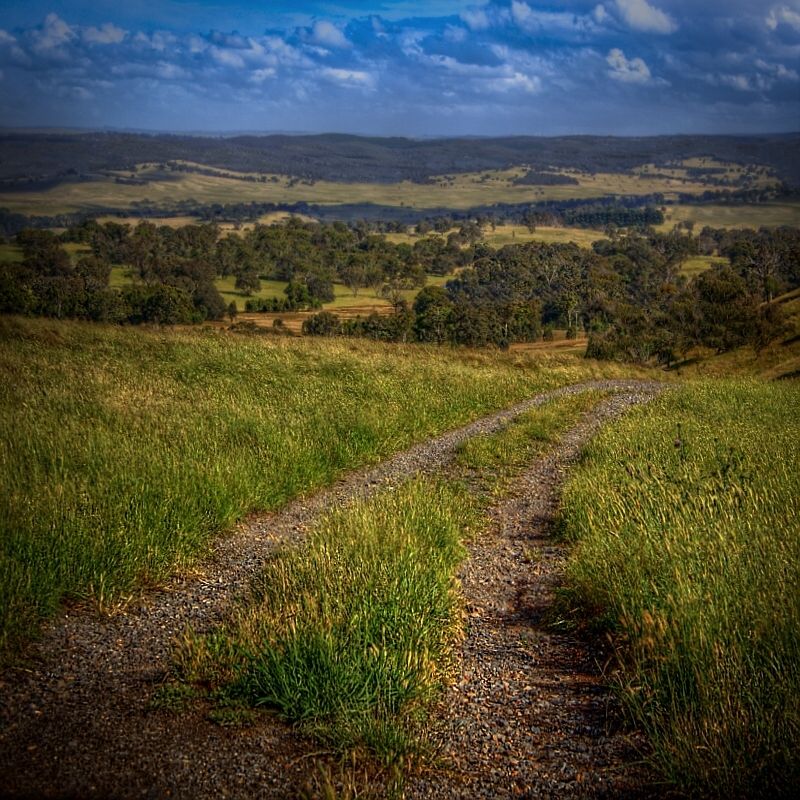
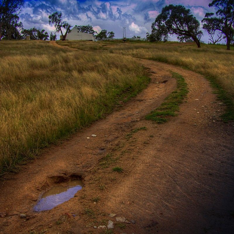
Spoonie, I enjoyed your trip report, greatly. The photos are very good and are very well seen. It is good to see a report with excellent images. Above the Wolgan shot, is just fantastic.
The track has been very soggy and has cut up a bit, since your trip.
It is drying out nicely now. Fingers crossed that the rain returns to normal summer falls. Several sections of the BNT in NSW and the ACT (and in FNQ there's a cyclone) are still closed because of low ground remaining soggy, land slides and sections of the track have been washed out and some bridges have been washed away.
You left the BNT at the Kelgoola turnoff near Native Dog Hill (?) and then headed east, well the BNT north of there to Widden, has been closed because of landslides and sections of the track have been washed away. National Parks have closed this section from Glen Alice to Myrtle Creek/Widden.
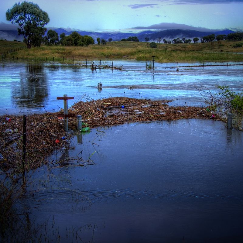
Closer to home (my home), the bridge crossing of Ginninderra Creek was several metres under water at one stage. The top of the flood gauge is (just) visible.
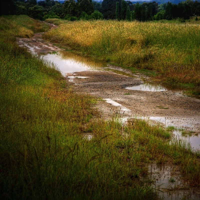
The crossing at Fassifern was well under from the flooding of the Gooramon Ponds wetlands.
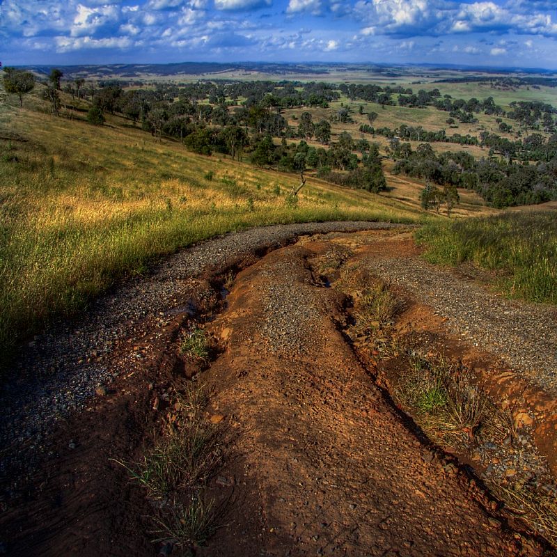
The swamp crossing under the Hume Hwy is worse than ever ... it is a really deep smelly ooze now. In the next shot, the decomposed granite from this track has washed into the tunnel blocking the drainage. I went and checked it out and ended going up over the Hume again. It looked only an inch deep.
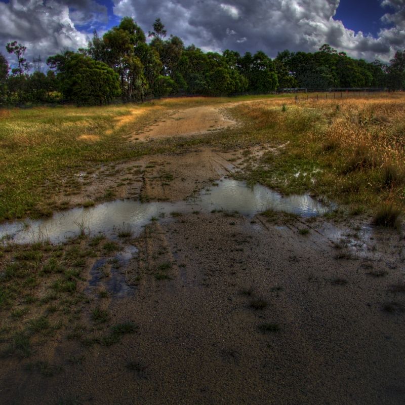
The amount of erosion to the track has gone from this to this. Making for a better bike ride I reckon.
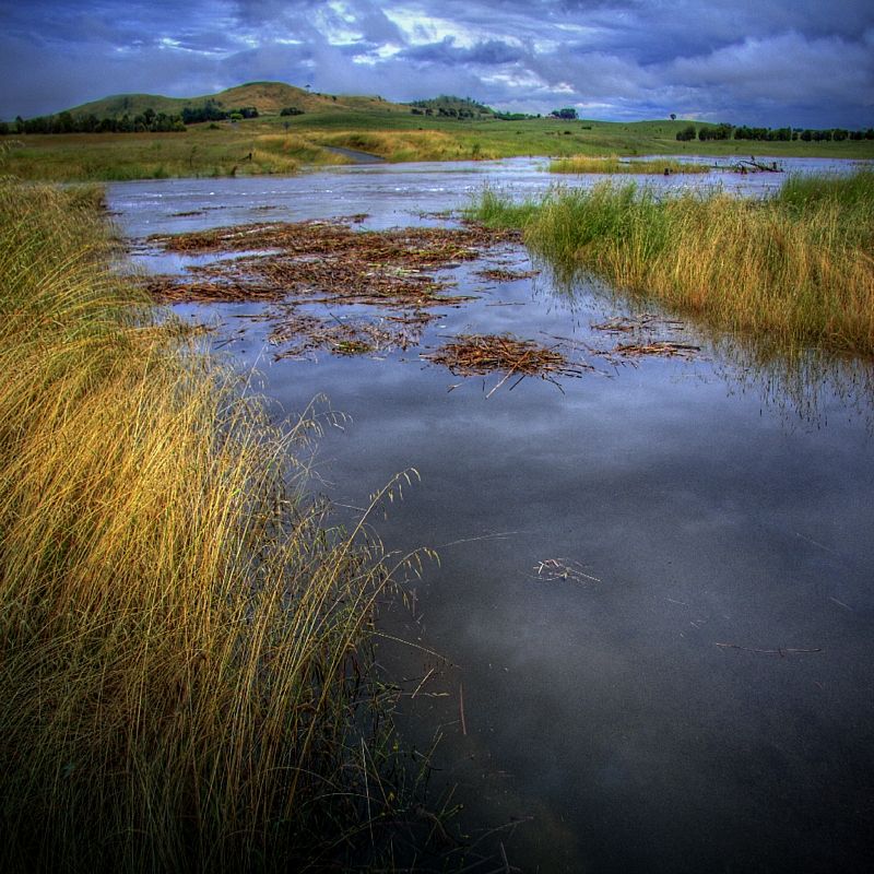
Lake George is still filling very nicely ... with more rain forecast.
... and possibly raining later today.
Again, your fine report, I've referred to others who are taking on the BNT.
Craig Cheers.
Warren.
The track has been very soggy and has cut up a bit, since your trip.
It is drying out nicely now. Fingers crossed that the rain returns to normal summer falls. Several sections of the BNT in NSW and the ACT (and in FNQ there's a cyclone) are still closed because of low ground remaining soggy, land slides and sections of the track have been washed out and some bridges have been washed away.
You left the BNT at the Kelgoola turnoff near Native Dog Hill (?) and then headed east, well the BNT north of there to Widden, has been closed because of landslides and sections of the track have been washed away. National Parks have closed this section from Glen Alice to Myrtle Creek/Widden.
Closer to home (my home), the bridge crossing of Ginninderra Creek was several metres under water at one stage. The top of the flood gauge is (just) visible.
The crossing at Fassifern was well under from the flooding of the Gooramon Ponds wetlands.
The swamp crossing under the Hume Hwy is worse than ever ... it is a really deep smelly ooze now. In the next shot, the decomposed granite from this track has washed into the tunnel blocking the drainage. I went and checked it out and ended going up over the Hume again. It looked only an inch deep.
The amount of erosion to the track has gone from this to this. Making for a better bike ride I reckon.
Lake George is still filling very nicely ... with more rain forecast.
... and possibly raining later today.
Again, your fine report, I've referred to others who are taking on the BNT.
Craig Cheers.
Warren.
Last edited:
{ScarFace}
Likes Dirt
Can anyone recommend any one-nighters in the blue mountains area? Also where I can get a hold of one of the BNT guidebook??? Sorry if I seem annoyingly naive